 |
| Colgate Clock - Clarksville, Indiana |
 |
| Exploring Indiana's Historic Sites, Markers & Museums South East Edition |
County - Clark
Area - 10.2 sq mi
Elevation 456 ft
Population - (2010) Total 21,724
ZIP codes - 47129
Area code(s) - 812
History
Pre-History
Amerindian tribes set up camps near the site of the current city because of the proximity of the Buffalo Trace, a route used by the buffalo to cross the Ohio River on their way to the salt licks in northern Kentucky. The State of Kentucky has preserved this site in the guise of Big Bone Lick State Park.
 |
| Lewis and Clark Expedition - Clarksville, Indiana |
George Rogers Clark and Clarksville
Clarksville, Indiana derives its name from Revolutionary War hero George Rogers Clark. He used the area in 1778 as a place to train his 175-man regiment for operations against the British at Vincennes, Kaskaskia and other British posts in what was to become the Northwest Territory in the new United States. After the war, Congress awarded George Rogers Clark 150,000 acres of land as payment for his services during the war in 1783. Known as the Clark Grant, this grant forms the nucleus of Clarksville and Clark County. 1,000 acres of this grant was set aside for the establishment of a town. A fort was constructed and a town grew up around it, the first American town established in the Northwest Territory.
 |
| A Visit to the Falls of the Ohio |
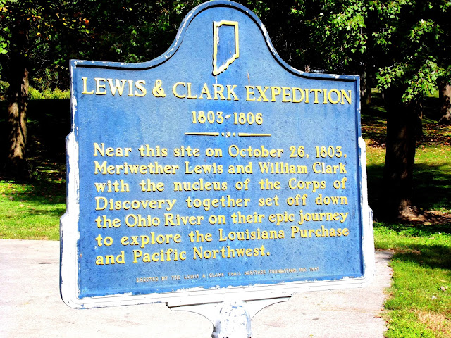
Because the town was the site where Meriwether Lewis and George Rogers Clark younger brother William shook hands and began organizing their now famous expedition, Clarksville lays a claim that it is where the expedition began.
The Indiana Canal Company
The Falls of the Ohio created a natural barrier to shipping on the Ohio River. This made Clarksville an ideal spot for a canal to bypass the falls and open the river to traffic from Pittsburg, Pennsylvania to New Orleans. Three attempts at building the canal, all of which failed, the first in 1805 with the creation of the Indiana Canal Company. The first effort failed, as did two later ones. A fourth attempt at Louisville, Kentucky succeeded. The loss of the canal and periodic flooding by the river made growth at Clarksville difficult. After World War II, the town began a period of growth that has continued to the present time.
 |
| Fossil Beds at Falls of the Ohio State Park - Clarksville, Indiana |
Falls of the Ohio State Park
The Falls of the Ohio State Park is found in Clarksville. Visitors can view the Ohio River Fossil beds as they walk the exposed riverbed.
Highways
I-65
US Route 31
Waterways
Ohio River
Attractions
Clarksville Little Theatre
Parks
Falls of the Ohio State Park
OHIO RIVER GREENWAY
Ashland Park
Beechwood Park
Cedar Park
Colgate Park
Gaskell Park
Gateway Park
Lapping Park
Lewis and Clark Park
Little League Park
Parkwood Park
Ray Lawerence Park
Aquatic Park
Wooded View Golf Course
Endris Lodge
Little League Complex
Softball Complex
Community Center
Auto Tour
Indiana Historic Pathways - South Spur
For dining, shopping and lodging information visit:
Clarksville, Indiana
2000 Broadway
Clarksville, IN 47129
info@townofclarksville.com
Welcome To Clarksville, Indiana
2000 Broadway St, Suite 221
Clarksville, IN 47129
(812) 283-5313
info@clarksvilleparks.com
315 Southern Indiana Avenue
Jeffersonville, IN 47130
812-282-6654
Comments
Post a Comment