Versailles/Holton/Friendship Driving Tour
Begin at the Ripley County Court House across the street from the Ripley County Historical Society and set your trip odometer at 0.
Drive towards First North Street, turn right. The street enters Cliff Hill Cemetery after passing the County Jail.
This is the site of Gordon’s Leap. There is a marker as you pass through the stone arch on the asphalt drive. Turn left onto the gravel drive. If you walk towards the fence you will see what Glass jumped off of. Also a great view of Versailles Lake and Versailles State Park below.
Continue around, you will exit on 2nd North Street
Continue on, crossing Monroe Street, Main Street. The next street is Washington Street. Turn Left.
You will cross First North Street, Tyson and Water. The next street is Perry. Turn left.
Perry Street becomes County Road 25 South.
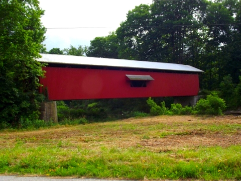
This road crosses the Bushing Covered Bridge at Mile Marker (MM) 1.8. When you exit the bridge, Versailles State Park is on your left.
Turn right as you exit the bridge.
You will come to US Route 50. Turn left, and then a quick right onto Cave Hill Road.
Cave Hill Road will make a sharp right hand turn and a sharp left hand turn. On this section of Cave Hill Road you are driving through Versailles State Park on both sides of the road until you turn east at the second elbow. About two miles from US Route 50 Cave Hill Road turns left and County Road 200 S goes straight. Stay on Cave Hill Road.
Continue south on Cave Hill Road. Please note that this is a narrow, winding county road. It is paved. If there have been heavy rains, the road may be flooded in portions as it follows very close to Laughery Creek. It is a very pretty drive through the hills and hollows of the Laughery Valley, so it is worth the trip.
At MM 8.5 Cave Hill turns right. You will want to cross the one lane concrete bridge.
Cave Hill Road ends at Indiana State Road 62 just west of Friendship, Indiana. MM 13.7
Turn left on State Road 62 and drive through Friendship.
Main Street/Indiana State Road 62 intersects Lincoln Street at a “T”. To continue tour, turn right.
*Note – The national headquarters of the National Muzzle Loaders Association is to the right and is visible from SR 62.
From Lincoln Street turn left on Hamlin Street.
From Hamlin Street turn right on Main Street and continue west on Main Street/Indiana State Road 62.
You will next intersect Indiana State Road 129. MM 17.5 To return to Versailles turn right. To continue the tour, continue straight on County Road 800S, which is straight ahead. Indiana State Road 62 turns left. You want to go straight.
County Road 800 S is pretty straight, but it passes through hilly terrain.
Intersect US Route 421. MM 24.1. If you wish to return to Versailles, turn right. To continue the tour turn left.
Continue on US Route 421 until you reach Michigan Road. MM 26.7 Turn Right.
There is an informational area here on the left pertaining to Morgan's Raid in Indiana and also Big Oak Nature Preserve.
Continue north on Michigan Road. This is one of the oldest highways in Indiana, built in the early 1800's to connect Madison, Indiana with Michigan City. US Route 421 follows some of the route of this early highway, but this section along Big Oaks National Wildlife Refuge follows the original route of this early, historic road.
Historical Marker Circuit Court MM 32.6.
Intersect US Route 50. MM 37.3 If you wish to return to Versailles, turn right. To continue the tour, turn left.
US 50 makes a slight bend at the intersection with Versailles Street in Holton, Indiana. MM 38.8. Turn right onto Versailles Street.
Holton Historical Marker MM 39.3 at the railroad tracks.
Turn right on Derrick Street MM 39.8 This road becomes 700 W.
700 W passes the Otter Creek Covered Bridge. MM 41.1
There is also a marker here for the Underground Railroad, Flat Rock Route, stop 2. This bridge and road was the road fugitive slaves traveled along this route aided by Ripley County residents as they fled slavery.
Intersect Hopewell Road at a "T". MM 43.7 Turn right at the "T".
This road is pretty straight, but narrow.
MM 46.4 Dabney Railroad crossing. Bear right, cross the tracks and Hopewell Road continues past the intersection with Michigan Road. Continue straight on Hopewell Road.
Intersect US Route 421. MM 50.7 Turn right.
*Note – one of the last remaining operating drive in theaters in Indiana is about one quarter mile to the left on US 421.
Intersect US Route 50. MM 51.
Intersection Adams Street at stop light. McDonalds on right. Turn left on Adams. MM 52.2.
Intersect Tyson Street. MM 52.3 Turn right.
Morgan’s Raid Tour Stop on right. MM 52.4
Turn left on Main. Tour end at Court House. MM 52.4
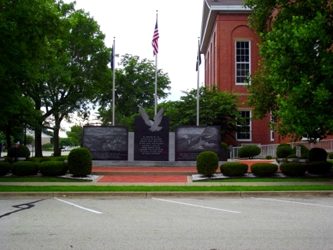
The Ripley County Veterans Memorial is located across the court house square.
 |
| Ripley County Court House |
Begin at the Ripley County Court House across the street from the Ripley County Historical Society and set your trip odometer at 0.
Drive towards First North Street, turn right. The street enters Cliff Hill Cemetery after passing the County Jail.
 |
| Cliff Hill Cemetery |
This is the site of Gordon’s Leap. There is a marker as you pass through the stone arch on the asphalt drive. Turn left onto the gravel drive. If you walk towards the fence you will see what Glass jumped off of. Also a great view of Versailles Lake and Versailles State Park below.
Continue around, you will exit on 2nd North Street
Continue on, crossing Monroe Street, Main Street. The next street is Washington Street. Turn Left.
You will cross First North Street, Tyson and Water. The next street is Perry. Turn left.
Perry Street becomes County Road 25 South.
 |
| Bushing Covered Bridge |
 | |
| Exploring Indiana's Historic Sites, Markers & Museums - South East Edition |
Turn right as you exit the bridge.
You will come to US Route 50. Turn left, and then a quick right onto Cave Hill Road.
Cave Hill Road will make a sharp right hand turn and a sharp left hand turn. On this section of Cave Hill Road you are driving through Versailles State Park on both sides of the road until you turn east at the second elbow. About two miles from US Route 50 Cave Hill Road turns left and County Road 200 S goes straight. Stay on Cave Hill Road.
Continue south on Cave Hill Road. Please note that this is a narrow, winding county road. It is paved. If there have been heavy rains, the road may be flooded in portions as it follows very close to Laughery Creek. It is a very pretty drive through the hills and hollows of the Laughery Valley, so it is worth the trip.
At MM 8.5 Cave Hill turns right. You will want to cross the one lane concrete bridge.
Cave Hill Road ends at Indiana State Road 62 just west of Friendship, Indiana. MM 13.7
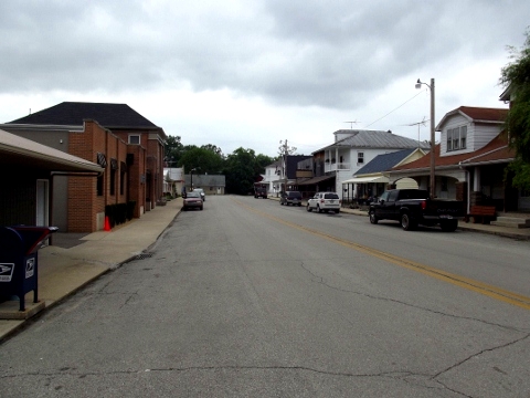
Turn left on State Road 62 and drive through Friendship.
 |
| Friendship, Indiana |
Main Street/Indiana State Road 62 intersects Lincoln Street at a “T”. To continue tour, turn right.
*Note – The national headquarters of the National Muzzle Loaders Association is to the right and is visible from SR 62.
From Lincoln Street turn left on Hamlin Street.
From Hamlin Street turn right on Main Street and continue west on Main Street/Indiana State Road 62.
You will next intersect Indiana State Road 129. MM 17.5 To return to Versailles turn right. To continue the tour, continue straight on County Road 800S, which is straight ahead. Indiana State Road 62 turns left. You want to go straight.
County Road 800 S is pretty straight, but it passes through hilly terrain.
Intersect US Route 421. MM 24.1. If you wish to return to Versailles, turn right. To continue the tour turn left.
Continue on US Route 421 until you reach Michigan Road. MM 26.7 Turn Right.
There is an informational area here on the left pertaining to Morgan's Raid in Indiana and also Big Oak Nature Preserve.
 |
| Morgan's Raid in Ripley County, Indiana |
Continue north on Michigan Road. This is one of the oldest highways in Indiana, built in the early 1800's to connect Madison, Indiana with Michigan City. US Route 421 follows some of the route of this early highway, but this section along Big Oaks National Wildlife Refuge follows the original route of this early, historic road.
Historical Marker Circuit Court MM 32.6.
Intersect US Route 50. MM 37.3 If you wish to return to Versailles, turn right. To continue the tour, turn left.
US 50 makes a slight bend at the intersection with Versailles Street in Holton, Indiana. MM 38.8. Turn right onto Versailles Street.
Holton Historical Marker MM 39.3 at the railroad tracks.
 |
| Holton, Indiana Historical Marker |
Turn right on Derrick Street MM 39.8 This road becomes 700 W.
700 W passes the Otter Creek Covered Bridge. MM 41.1
 |
| Otter Creek Covered Bridge |
There is also a marker here for the Underground Railroad, Flat Rock Route, stop 2. This bridge and road was the road fugitive slaves traveled along this route aided by Ripley County residents as they fled slavery.
Intersect Hopewell Road at a "T". MM 43.7 Turn right at the "T".
This road is pretty straight, but narrow.
MM 46.4 Dabney Railroad crossing. Bear right, cross the tracks and Hopewell Road continues past the intersection with Michigan Road. Continue straight on Hopewell Road.
Intersect US Route 421. MM 50.7 Turn right.
*Note – one of the last remaining operating drive in theaters in Indiana is about one quarter mile to the left on US 421.
Intersect US Route 50. MM 51.
Intersection Adams Street at stop light. McDonalds on right. Turn left on Adams. MM 52.2.
Intersect Tyson Street. MM 52.3 Turn right.
Morgan’s Raid Tour Stop on right. MM 52.4
Turn left on Main. Tour end at Court House. MM 52.4
The Ripley County Veterans Memorial is located across the court house square.
 |
| Ripley County Veterans Memorial |
Comments
Post a Comment